Mark Wickens
ADIF Processor
Documentation last updated: 03-MAY-2024
Please consider joining the adifproc groups.io group for update announcements, bug reports etc.
Table of Contents
- ADIF Processor
- Examples
Introduction
The ADIF Processor is an online application that visualizes amateur radio contacts from an ADIF log file using Google Earth. SOTA CSV log files can also be used.
As well as allowing you to view and explore your contacts in Google Earth, you will be able to:
- see a Markdown or text table of contacts.
- use the output ADIF file which contains QRZ.com data, accurate contact distances and fields populated from comments in the input file.
- print QSL labels.
One of the benefits of using the ADIF Processor before uploading/storing your ADIF file is detecting errors in callsigns and activity references (e.g. POTA or SOTA references).
A high-level overview of the process is shown below:
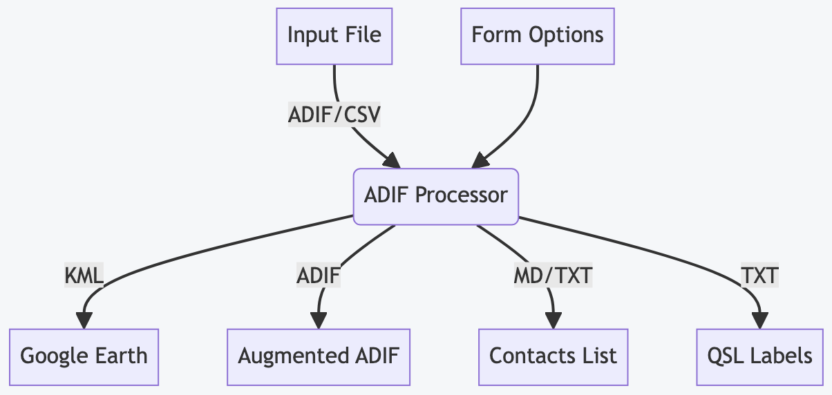
The processor also produces a Markdown format contact table for pasting into a reflector, or a plain text contact list, and can generate labels for QSL cards.
I recommended following the Quick Start section below to get a feel for the tool, then have a look at the advanced options based on your requirements.
Quick Start
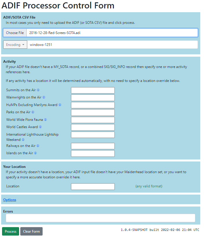
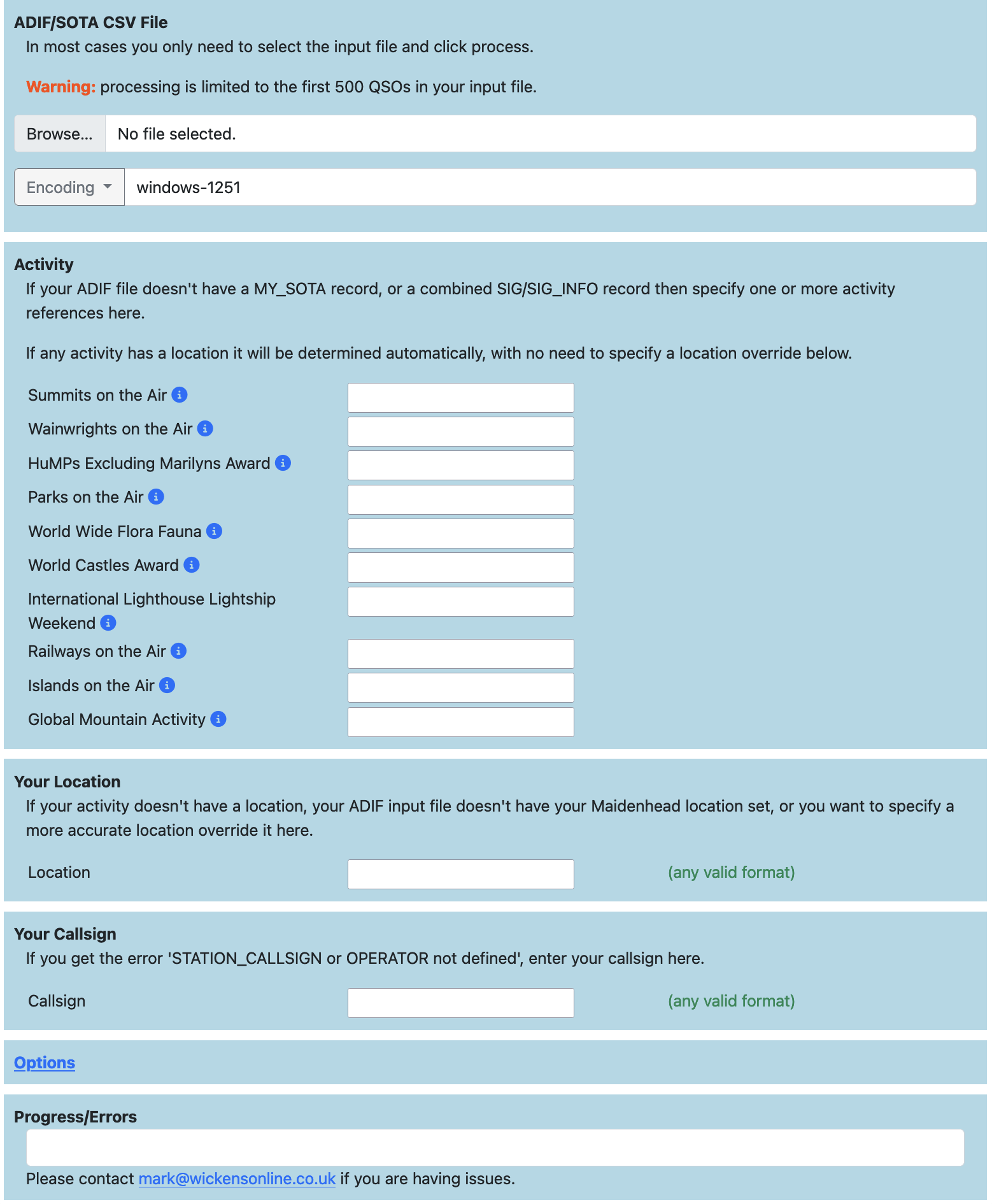
Select your ADIF or SOTA CSV file on the
ADIF Processor upload form
and click Process...
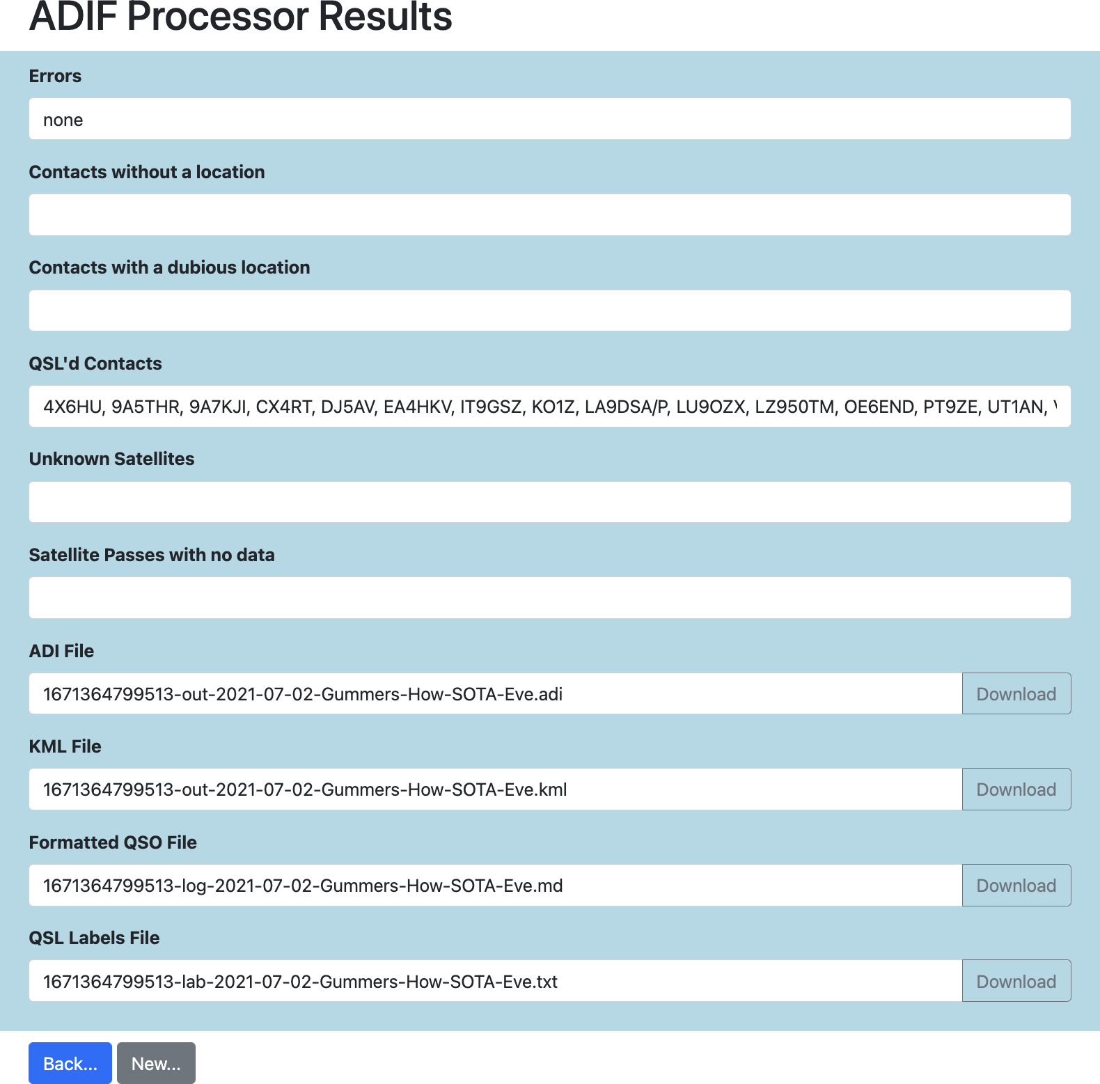
You will be presented with four files to download, as required:
- a Google Earth Project (KML) file.
- an enhanced ADIF file
- a contact list in either Markdown or plain text format
- a QSL label file
Any processing errors are displayed in the Errors text box.
Any callsigns for which a location could not be determined are shown in the Callsigns without Location text box.
In a lot of cases you simply select your ADIF file and process it, no other options are required.
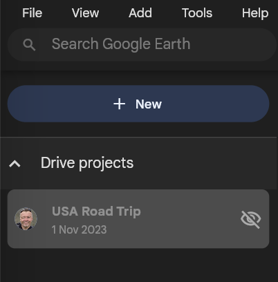
To see your QSOs on the desktop browser based Google Earth use Import KML file from computer via the map pin icon. In Android Google Earth simply click on the downloaded ADIF file.
Desktop/Browser Google Earth New Option
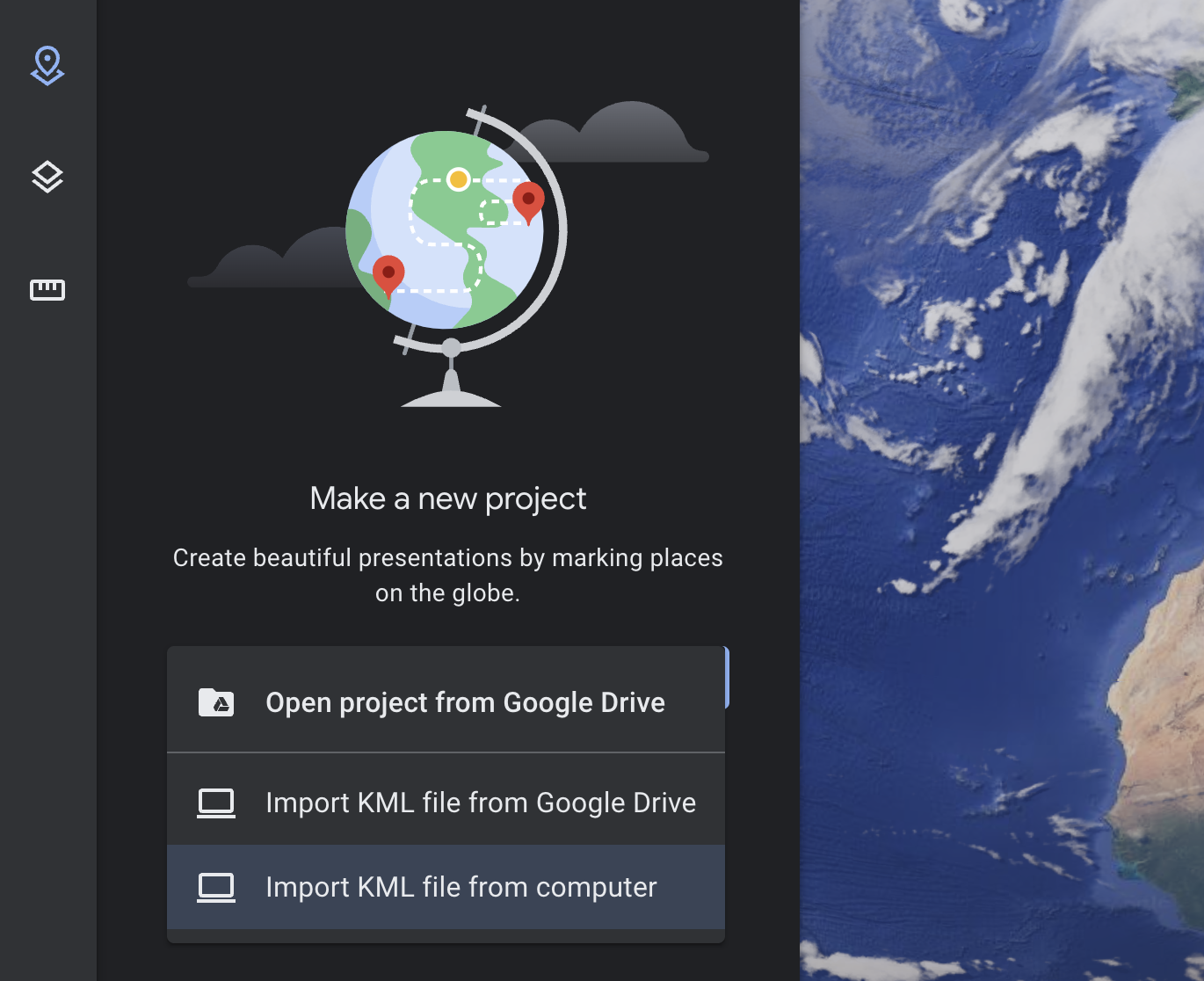 Import option on the Google Earth menu
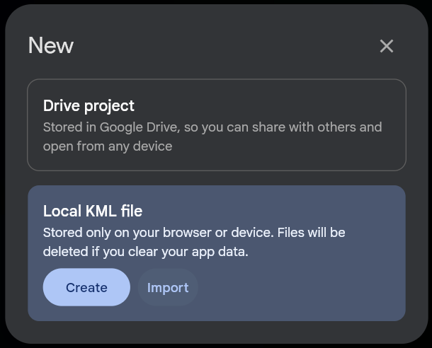
Desktop/Browser Google Earth Local KML Import Dialog
If the ADIF Processor cannot determine your location then you specify it using any common location format (lat/long, maidenhead, an address etc.) in the Location text field.
TIP:
An easy way to find your location is to right-click on Google Maps and select
the Latitude & Longitude value which will copy the value onto the clipboard.
This can then be pasted directly into the Location text box.
Some ADIF files, predominantly those automatically generated for data-mode contacts, don’t include your callsign. If you get an error ‘STATION_CALLSIGN or OPERATOR not defined’ then specify your callsign in the ‘Callsign’ form field.
What is an activity? - any of the supported contests/challenges listed on the ADIF Processor form, such as Summits on the Air for example.
If you’re logging for one of the supported activities you should enter the activity reference if it isn’t included in your input file. Your location will be determined from the activity if possible.
More Infomation about ADIF Processor
Virtually all Ham Radio Logging programs have the ability to produce ADIF files. ADIF stands for Amateur Radio Interchange Format and was designed to allow logging applications to export and import contacts without loosing any information. As such it supports a large number of fields designed to capture every aspect of a QSO.
You may have connected your logging application to QRZ.COM. If you have an XML Subscription membership contact details can be automatically pulled from QRZ.COM.
However, if you use a standalone program such as Fast Log Entry then the data that you enter as part of the QSO log will be the total information available in the ADIF export.
The ADIF Processor will to add information from QRZ.com. Activity references pull are used to locate portable operators and add information about the activity.
Using specially-formatted information in the COMMENT field you can populate the correct fields in the output
ADIF file.
This works really well for Fast Log Entry with only limited support for ADIF fields built into the application.
How the ADIF Processor Works
There are a number of steps the ADIF Processor performs as it turns your ADIF file into a Google Earth KML project file. Key is identifying a location for each end of a contact.
Determining Your Station Location
Lots here depends on whether you are operating from a fixed location or portable.
If you are fixed the simplest solution is to ensure your QRZ.COM entry has a latitude & longitude for the most accurate location.
If you aren’t a fan of QRZ.COM you can override your location on the form either by specifying a latitude or longitude, or alternatively a Maidenhead Locator.
If you want to obscure your location then specify a 6 or 8 character locator rather than the most accurate 10 character version.
If your location isn’t fixed (/P, /M, /A) use one of the following to let the ADIF processor know where to place you:
- ADIF input file contains a
MY_SOTA_REF,MY_POTA_REF,MY_WWFF_REF - A supported activity and reference in the
MY_SIG_INFO&MY_SIG_REFfields, where that activity has a location - Specify
MY_GRIDSQUAREorLATITUDE&LONGITUDE.
If none of these are an option for you then let the processor know where you are via the form, either by specifying an activity reference, or directly entering your location.
The Location field on the form supports any of the coordinate formats you can use in the Coordinate Converter, for example:
- Latitude and Longitude, eg: 54.3709 -2.9099 or 54° 22.260’ N, 3° 5.403’ W
- Maidenhead Locator (4/6/8/10 character), eg: IO84NI
- Activity Reference in the SOTA/WOTA/LOTA/POTA/ROTA/COTA/WWFF programmes eg: G/LD-050
- An OSGB36 British National Grid Reference, 4 or 5 digit, eg: SD 40891 97674
- An OSGB36 British National Grid Easting/Northing, eg: E 332222, N 527763
- A street address for geocoding
Determining Other Station Locations
For each of your hard earned contacts ADIF Processor attempts to determine a location. It does this using a number of techniques, in order of accuracy:
- A
LATITUDEandLONGITUDEin the ADIF file. - Their Activity location (in the
SIGandSIG_INFOorSOTA_REFfields of the ADIF input file). - Location in QRZ.com, preferring Latitude & Longitude if set over Maidenhead locator.
- A maidenhead locator in the ADIF file
GRIDSQUARE. - A Geocoding lookup is made via Nominatim and the OpenStreetMap database using any QRZ.com address data.
Note that a number of locations are regarded as dubious or invalid based on them being the default grid or latitude/longitude location in QRZ.com. In these cases unless an override location is specified in the input ADIF file a Geocoding lookup is made to determine the station location.
Stations without a location
Where no location can be determined a warning is issued, and the station isn’t added to the Google Earth KML file.
You can correct this by adding an activity for the station,
or by specifying their LATITUDE and LONGITUDE in the ADIF input file or their GRIDSQUARE reference.
Adding Station Information from QRZ.COM
In order to enrich the ADIF output file, and provide more information when you click on a station icon in Google Earth, a lookup is made for additional station information from QRZ.COM.
The initial lookup is for the callsign as logged, but for some callsigns more work is required to determine the information.
The worst case is a portable operator abroad. It is unlikely the operator has created a specific QRZ.COM page for this callsign. I’ll use examples to show how the application tries to determine the most accurate information.
When operating on holiday in Spain I used the callsign EA7/M0NOM/P. If you had a contact with me and
used the ADIF Processor it would check QRZ.COM for the following callsign variants in order:
EA7/M0NOM/PEA7/M0NOMM0NOM/PM0NOM
The UK complicates this a little more, as a Scottish operator MM0XRT activating a HEMA summit in Wales
would be MW0XRT/P. In this case QRZ.COM would be queried with UK country callsign variants:
MW0XRT/PMW0XRTM0XRT/PM0XRTMM0XRT/PMM0XRTMI0XRT/PMI0XRTMD0XRT/PMD0XRTMG0XRT/PMG0XRT
As soon as a variant matches in QRZ.COM the search stops. I’ve almost certainly only scratched the surface on this process!
Station Icons in Google Earth
Each station in the Google Earth project file has an icon. The icon used depends on the callsign suffix or if a station has been recorded doing an activity.
Here are the possible icons:
| Icon | Suffix | Activity | Description/Link |
|---|---|---|---|
 |
none or /A | At home or alternate address | |
 |
/P | Portable | |
 |
/MM | Maritime Mobile | |
 |
/AM | Aeronautical Mobile | |
 |
/M | Mobile | |
 |
/P | SOTA | Summits on the Air |
|
/P | GMA | Global Mountain Activity |
 |
/P | HEMA | HuMPs Excluding Marilyns Award |
 |
/P | POTA | Parks on the Air |
 |
/P | COTA | World Castles Award Programme |
 |
/P | WOTA | Wainwrights on the Air |
 |
/P | WWFF | World Wide Flora & Fauna in Amateur Radio |
 |
LOTA | International Lighthouse & Lightship Weekend | |
 |
ROTA | Railways on the Air | |
 |
IOTA | Islands on the Air | |
 |
BOTA | Bunkers on the Air |
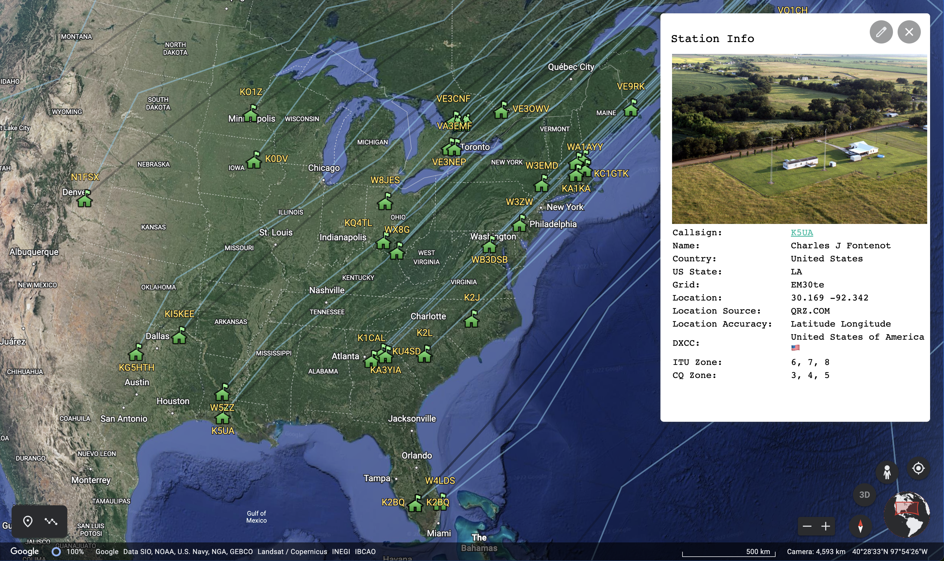
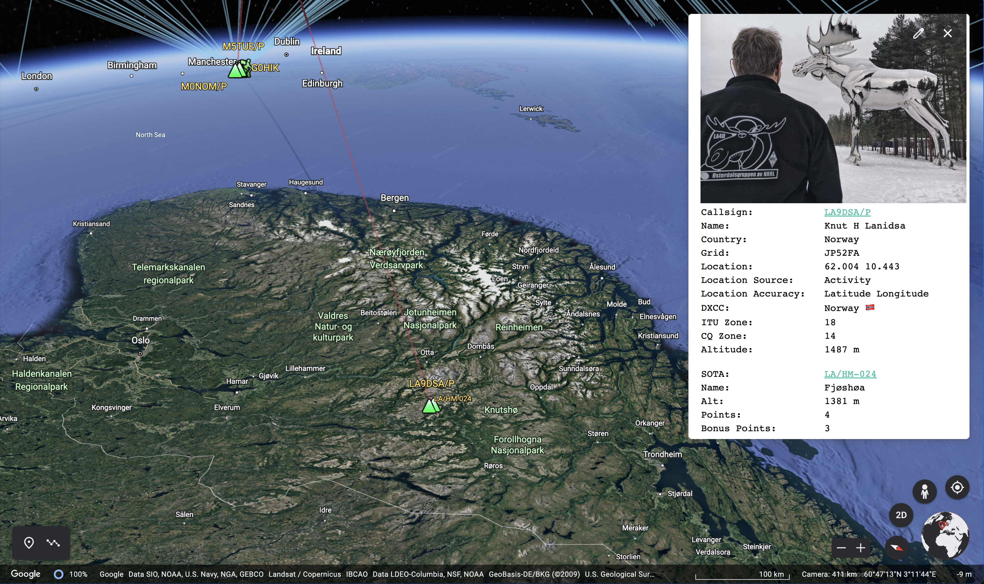
Stations are selectable on the Google Earth map, or by selecting the station in the project list. When you do this a panel of information about the station is displayed. If the operator has a picture on QRZ.COM this is displayed together with details of activity the station was participating in and the frequency and mode of contact.
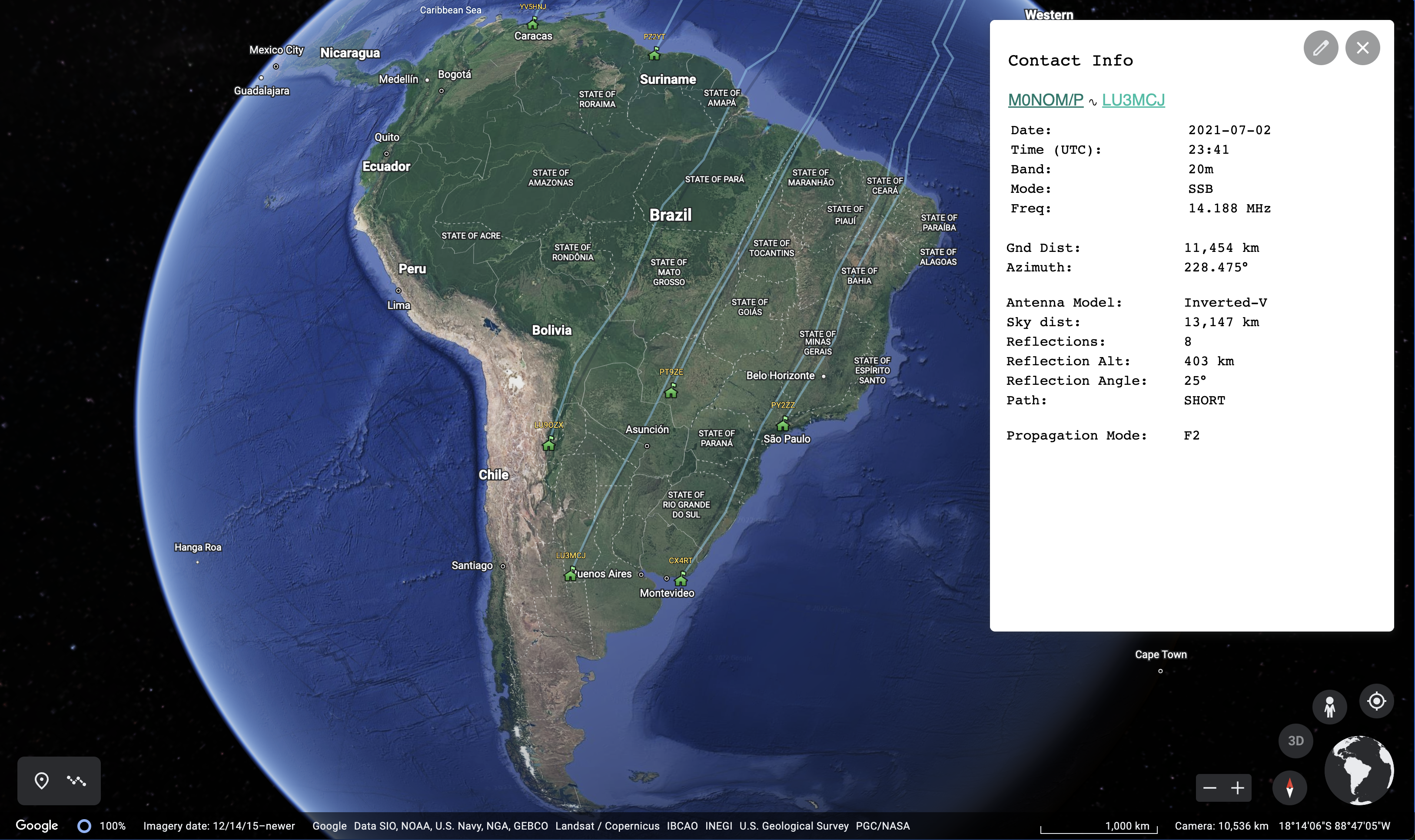
The communication paths between stations are also selectable directly from the line drawn on the Google Earth visualization (noting that a ‘shadow’ dark gray line is also drawn to help with the visualization) or from the project list.
When you select a communication path a panel of information is displayed that contains both station callsigns,
together with the date and time of the contact and the propagation mode. For SKYWAVE contacts the number
of reflections is displayed together with the bounce height, length of contact across the surface of the earth as
well as the distance the predicted path of communication took.
Visualizing a QSO
ADIF Processor uses a simple propagation visualization technique based on an ideal antenna. For HF signals this gives an idea of the minimum number of hops your QSO would have needed to reach the target station.
The Propagation Model
This is a very simple model designed to map both HF and VHF/UHF contacts.
It supports predicting SKYWAVE, GROUNDWAVE and SPORADIC_E propagation modes. You can specify
TROPOSPHERIC_DUCTING for contacts identified as using this propagation.
If you use INTERNET as the propagation mode comms lines are drawn across the Earth directly between
stations.
Where the distance between two stations using HF is short it is assumed that the communication
path is GROUNDWAVE.
This is the logic applied in determining the propagation mode. Note that there can be considerable improvements made to this model, but any model is only ever going to be a ‘best guess’.
| Frequency | Distance | Classification |
|---|---|---|
| 𝑓 > 50 MHz | < 400 km | GROUNDWAVE |
| 𝑓 > 50 MHz | > 400 km | SPORADIC-E |
| 7 MHz > 𝑓 > 50 MHz | < 400 km | GROUNDWAVE |
| 𝑓 < 7 MHz | >= 400 km | SKYWAVE |
This is a very, very rough approximation. A future enhancement will make the model configurable, and ideally would be able to take into account propagation measurements and conditions at the time of the contact to help improve the accuracy of the visualization.
VHF Contacts
For Groundwave VHF+ contacts the model applies an algorithm to determine a nominal ‘bounce height’
which is a very crude approximation of the curved signal paths that take place in reality. The algorithm
defines the bounce height as 6 x the distance between two contacts in km, and if possible takes into
account the height of the stations if that is available from any activities taking place. In general
this ensures that the visualization of the signal path between two stations using GROUNDWAVE is
visible above the earth that runs underneath the path. This isn’t always the case where a contact
is made from a high to low point or where there is terrain in-between.
Tropospheric Ducting
In order to visualize a contact that has been via
tropospheric ducting
you must set the PROPAGATION_MODE to TR in the ADIF input file for that contact.
If you are using Fast Log Entry to create your ADIF file add the comment PROP_MODE: TR.
The model used is a duct at height 2,000m and a duct width of 500m, so the signal bounces in a duct between 2,250m and 1,750m. These value represent an ‘average’ duct height and width.
HF Contacts
HF contacts are modelled using a reflection angle that is frequency dependent. In the Options pane you can choose from a number of different antenna models, with different angles of radiation.
| Antenna | Radiation Angle |
|---|---|
| Vertical | 15° |
| YAGI | 10° |
| Dipole | 20° |
| Inverted-V | 25° |
This is a very crude approximation of the reality. It affects the number of calculated reflections, with many more reflections for example when using an Inverted-V compared to an HF YAGI.
Long Path HF Contacts
If you want to visualize long path contacts specify either the ANTPATH ADIF parameter as L in the
ADIF input file, or specify PATH: L in the COMMENT field of the ADIF input file.
Long path contacts are visualized using a path that is 180 degrees reversed from the shortest path azimuth. The antenna direction specified in the ADIF input file isn’t currently used during modelling.
Activities
The ADIF Processor knows about activities. The term Activity is used to describe a special activity that you or the contacted station are participating in. For example: Summits on the Air or Parks on the Air. For each activity the ADIF Processor loads the database of activity references. The totals are currently:
- 166,398 Summits on the Air
- 40,115 Parks on the Air
- 51,138 World Wide Flora & Fauna
- 1,178 Islands on the Air
- 3,329 Humps on the Air
- 330 Wainwrights on the Air
- 29,727 Global Mountain Activity
- 65,912 Castles on the Air
- 1,706 Lighthouses on the Air
- 37 Railways on the Air
- 2,011 Bunkers on the Air
Specific activity notes:
Summits on the Air
Summits on the Air references can be used to accurately define the operator’s location, as the programme requires them to be within 25m vertical of the actual summit. If you want to be more accurate you can override the location.
Parks on the Air
The ADIF format 3.1.4 allows for multiple Parks on the Air references to be specified, as the operator may have multiple park references. For example. Whitbarrow Scar in the Lake District is both its’ own POTA reference G-0190 Whitbarrow National Nature Reserve and is also contained in G-0165 Lake District National Park, so both parks are activated at the same time. Where there are multiple activity references the first reference is used as the operator location, so if you are listing more than one park use the most accurate reference first, or specify the operators’ location.
As another example if you are activating G-0165 Lake District National Park you should override the location of the operator as the location specified for the POTA reference is a central marker for the entire national park.
WWFF
World-wide Flora Fauna locations may or may not have a location specified, therefore it is generally best to override the location of the operator.
Islands on the Air
Locations are approximate, depending on the size of the island, so a location should be specified for the operator.
Humps on the Air
Locations are summit references and are accurate, so the HEMA reference is normally good enough.
Wainwrights on the Air
Locations are summit references and are accurate, so the WOTA reference is normally good enough.
Global Mountain Activity
Locations are summit references and are accurate, so the GMA reference is normally good enough.
Castles on the Air
Locations are the location of the castle and are generate accurate, so normally good enough.
Lighthouses on the Air
Locations are the location of the lighthouse or lightship, so normally good enough.
Railways on the Air
I update the location of the railways on the air references every year, so they are generally good enough.
Bunkers on the Air
Locations are bunker references and are accurate, so if you are near the bunker then the reference is good enough. As the activation zone is a 1km square around the bunker, if you are activating at any distance from the bunker consider providing a more accurate location reference.
Satellite Support
Satellite Support is documented on a separate page.
The ADIF format 30 second Primer
ADIF Amateur Data Interchange Format is a text file representation for Amateur radio contacts. It is a popular output format for logging programs. The ADIF specification describes the valid content of the header and record fields.
An ADIF file consists of two sections:
- header
- records
Fields in an ADIF file
Each field in the file is proceeded by a field name separated by the length of the field value with a colon.
For example: <PROGRAMID:3>FLE indicates the field is PROGRAMID and the text contained in the field
is 3 characters long with a value of FLE.
Header
The header contains information about the program that generate the file and the ADIF version, for example:
ADIF Export for Fast Log Entry by DF3CB
<PROGRAMID:3>FLE
<ADIF_VER:5>3.1.0
<EOH>
The header is terminated with the <EOH> marker.
Records
Each record captures all the details of a QSO for both the recording station and the contacted station.
A record is terminated by the <EOF> marker.
Here is an example entry in a Fast Log Entry input file:
40m ssb 7.090
1258 g7las/p 7.188 <OP: Rob, PWR: 50, GRID: IO81LC, HEMA: G/HWB-026>
This is the ADIF record generated by Fast Log Entry. These are typically stored on one line. In this case I’ve separated each field of a record into a single line:
<STATION_CALLSIGN:7>M0NOM/P
<CALL:7>G7LAS/P
<QSO_DATE:8>20210522
<TIME_ON:4>1258
<BAND:3>40m
<MODE:3>SSB
<FREQ:5>7.188
<RST_SENT:2>59
<RST_RCVD:2>59
<COMMENT:47>OP: Rob, PWR: 50, GRID: IO81LC, HEMA: G/HWB-026
<QSLMSG:44>Thx for QSO from Winter Hill io83ro G/SP-010
<MY_SOTA_REF:8>G/SP-010
<OPERATOR:5>M0NOM
<MY_GRIDSQUARE:6>IO83ro
<EOR>
Note that the QSO has a <STATION_CALLSIGN:7> (me) and a <CALL:7> G7LAS/P who is on the other end,
a date and time, frequency, band, mode, signal reports,
my SOTA reference <MY_SOTA_REF:8>, the operator (basically my callsign without any modifiers) and my
Maidenhead Locator in <MY_GRIDSQUARE:6>.
Of interest is the comment line, which we will examine further, as this is one of the key features of post-processing. In the comment line:
<COMMENT:49>NAME: Rob, PWR: 50, GRID: IO81LC, HEMA: G/HWB-026
You will notice that it consists of a number comma-separated key-value pairs. For example, the first
pair key is NAME with value Rob, then PWR value 50 etc.
The Comment Field in your ADIF file
The ADIF Processor looks carefully for keyword/value pairs in the comment field in your ADIF input file. The keyword should be followed by a colon, and a comma may optionally separate each key/value pair. If the ADIF Processor recognises a keyword then it acts on the key/value pair to add additional information to the ADIF output file in the correct ADIF field.
For example a comment like: HEMA: G/HLD-001, NAME: Mark, RIG: FT-817, PWR: 5
would be processed one key/value pair at time and would result in the following ADIF fields being set:
| ADIF Field | Value |
|---|---|
| SIG | HEMA |
| SIG_INFO | G/HLD-001 |
| NAME | Mark |
| RIG | FT-817 |
| RX_PWR | 5 |
Supported Comment Name/Value pairs
The ADIF Processor supports all ADIF field names, as defined in the ADIF Specification. See the ADIF Fields & Types page for a complete list.
In addition to the standard field names, a number of shortcuts are supported, as specified in the table below.
In the table below the Comment Key column shows the keyword you should specify if you want to add
additional information in the ADIF output file. See the Sample Value column for an example of the
data to be provided. Activity references must use the correct syntax. The Target ADIF Field column
show where the data will be located in the ADIF output file.
In each case (unless noted) these values refer to the contact station information.
For activity references specifying a reference that has an associated location will also set their
LAT & LONG value for the location associated with the activity reference (unless that location
has been overriden explicitly).
| Description | Comment Key | Sample Value(s) | Target ADIF Field |
|---|---|---|---|
| Coordinate† | COORD |
50°50’56”N 14°38’49”E | LATITUDE & LONGITUDE |
| Islands on the Air Ref. | IOTA |
E-145 | IOTA |
| Parks on the Air Ref. | POTA |
G-0190,G-0165 | POTA_REF |
| Summits on the Air Ref. | SOTA |
G/LD-001 | SOTA_REF |
| Castles on the Air | COTA |
DL-03609 | SIG/SIG_INFO |
| Humps on the Air Ref. | HEMA |
G/HLD-001 | SIG/SIG_INFO |
| Wainwrights on the Air Ref. | WOTA |
LDW-001 | SIG/SIG_INFO |
| Worldwide Flora Fauna Ref. | WWFF |
GFF-0233 | SIG/SIG_INFO |
| Lighthouses on the Air Ref. | LOTA |
UK0019 | SIG/SIF_INFO |
| Railways on the Air Ref. | ROTA |
GB4LHR | SIG/SIG_INFO |
| Bunkers on the Air Ref. | BOTA |
B/GW-0173 | SIG/SIG_INFO |
†Coordinate can be specified in most latitude/longitude formats including decimal, degrees minute seconds, degrees decimal minutes etc.
When using Fast Log Entry, format your comment next to your QSO record between angle brackets, for example:
2111 g7tcq/m  59 59 <QTH: M6 J11 N. Birmingham, PROP: TR> #IO82xq
2118 g4iog    55 52 <NAME: Bob RIG: FT-991 PWR: 50w QTH: Sittingborne PROP: TR>
Note that each keyword must be followed by a colon and each pair may be followed by a comma. If you are specifying a latitude/longitude pair you can use comma separated values (for example when pasted in from Google Maps).
To add information to go in the
COMMENT field of the ADIF file directly use a key of COMMENT, or use a key of NOTES to specify
information to go in the ADIF NOTES field.
Propagation Modes
These are the valid values for the propagation modes that the ADIF Processor currently supports
that can be specified in the ADIF field PROP_MODE or via the Fast Log Entry comment key
PROP:
| Value | Mode |
|---|---|
| empty | Predict |
TR |
Tropospheric Ducting |
ES |
Sporadic E |
F2 |
F2 Reflection |
INTERNET |
Internet-based |
If the mode isn’t specified then it is predicted. Note that the prediction model doesn’t include Tropospheric Ducting, you need to specify that manually. The distance achieved by UHF/HVF contacts varies enormously based on location, antenna and mode so long-distance point-to-point contacts are entirely feasible.
 Example of Tropospheric Ducting Visualization
Background of the Project
The ADIF Processor started as a project to allow me to add additional information in the comment field of a Fast Log Entry input file. This meant I could specify things like operator name, rig, their power and activity references, that couldn’t be populated directly from Fast Log Entry.
As I like to record the contacted station location as accurately as possible I then decided to add support for up-to 10 character Maidenhead Locator references and at that point stumbled across the idea of visualizing QSOs using Google Earth. There isn’t much support for 10 character Maidenhead locators in the mapping tools currently available. The aprs.fi site allows 10 character Maidenhead locators to be entered. When out in the field I use the HamGPS Android application to determine my 10 character Maidenhead locator.
Source Code
ADIF Processor is written in Java as a Spring Boot Application. It makes use of the following separate GitHub projects.
ADIF Library
A fork of the ADIF library by Martin Sivák. I have made some corrections and enhancements to the original library.
The adif-processor
The adif-processor contains the main functionality of ADIF Processor.
All the code to generate the enhanced ADIF file, interact with QRZ.COM, load the activity databases, generate the KML file and generate the Markdown file is contained in this project.
The adif-processor contains a standalone, command-line based main application file, so it can be used directly from the command line without a web interface.
There is a comprehensive set of command line options. See the project README.md for more information.
The ADIF Web Front end
The adifweb project contains the web-based interface to the adif-processor. The version you are using is a Bootstrap based spring-boot web application that is hosted as an AWS Elastic Beanstalk project.
Examples
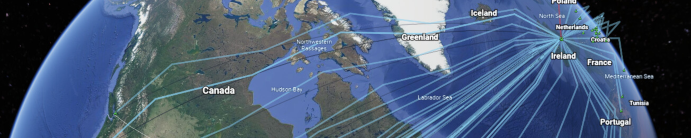
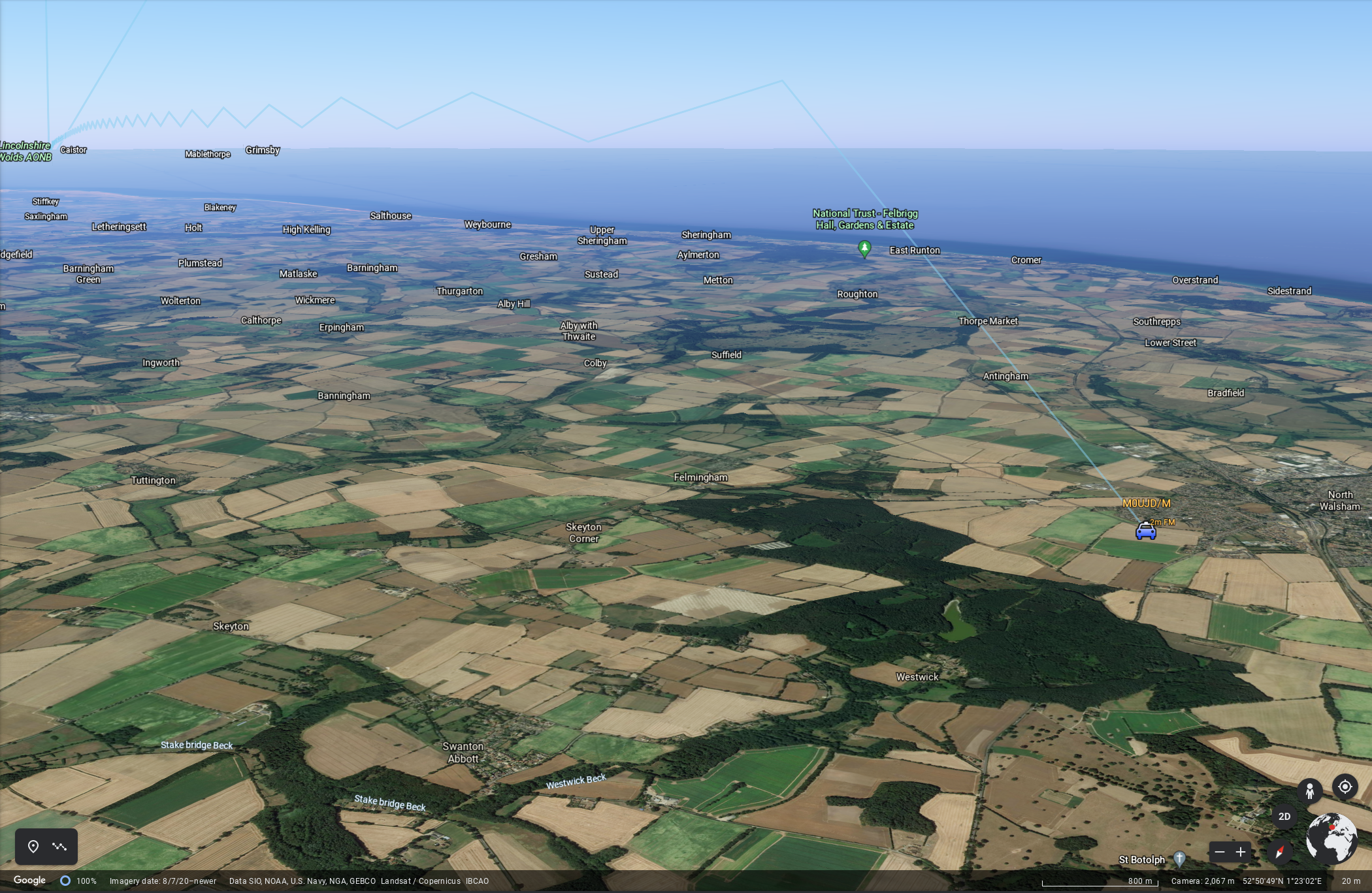
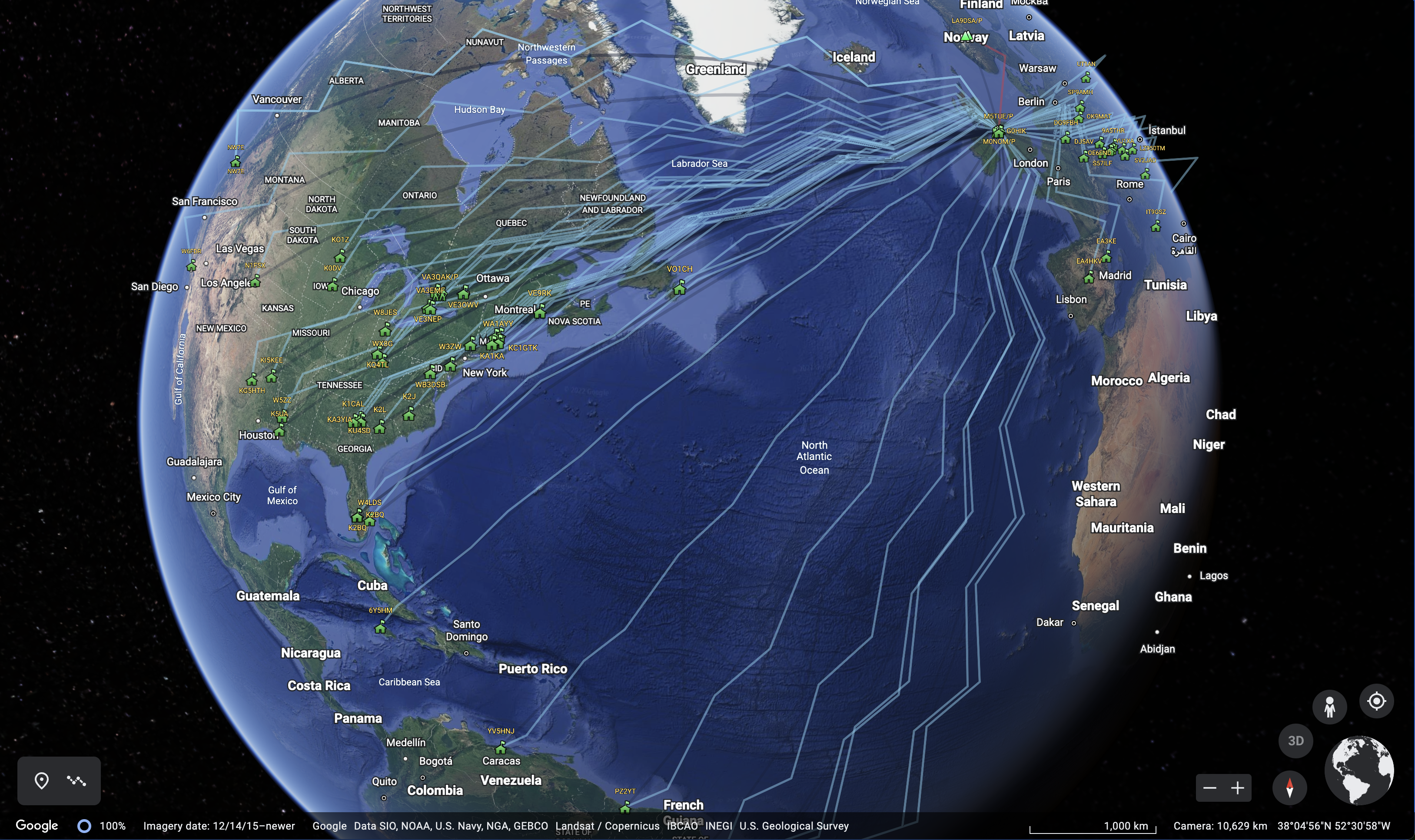
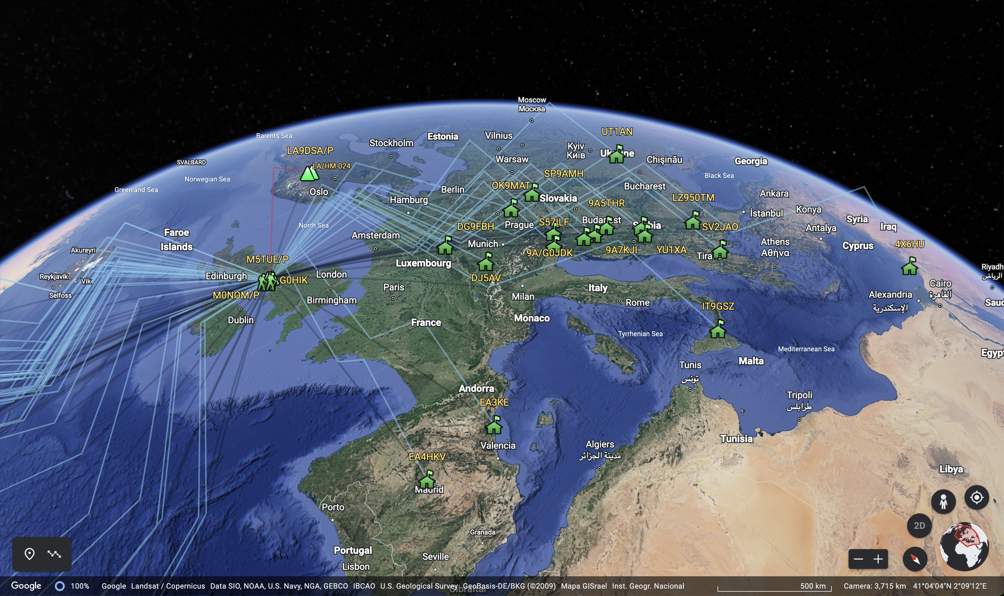
Google Earth KML Project Images
Here are some example Google Earth images from an evening activation of SOTA Summit Gummer’s How G/LD-050.

Example Markdown Contacts List
| TIME | CALLSIGN | BAND | MODE | RST | RSR | OPERATOR | SIG | REF |
|---|---|---|---|---|---|---|---|---|
| 19:45 | EA3KE | 20m | SSB | 59 | 59 | Tony | ||
| 20:05 | 9A/G0JDK | 20m | SSB | 59 | 59 | Alan | ||
| 20:08 | M5TUE/P | 2m | FM | 59 | 59 | Nigel | ||
| 20:24 | G0HIK | 2m | FM | 59 | 58 | Nick | ||
| 20:31 | 9A5THR | 20m | SSB | 59 | 59 | Tomy | ||
| 20:39 | LA9DSA/P | 40m | SSB | 59 | 59 | Knot | SOTA | LA/HM-024 |
| 20:46 | YU1XA | 20m | SSB | 59 | 59 | Blagomir | ||
| 20:51 | EA4HKV | 20m | SSB | 59 | 56 | Jorge | ||
| 20:59 | DG9FBH | 20m | SSB | 59 | 59 | Lota | ||
| 21:08 | LZ950TM | 20m | SSB | 59 | 59 | Bulgarian | ||
| 21:10 | IT9GSZ | 20m | SSB | 59 | 59 | Nunziato | ||
| 21:22 | PZ2YT | 20m | SSB | 59 | 56 | Yudel | ||
| 21:29 | CX4RT | 20m | SSB | 59 | 57 | Juan | ||
| 21:50 | K2J | 20m | SSB | 59 | 59 | 13 | ||
| 21:56 | W3ZW | 20m | SSB | 53 | 55 | Wilf | ||
| 21:58 | YT2MDM | 20m | SSB | 59 | 59 | Vlad | ||
| 22:01 | DJ5AV | 20m | SSB | 59 | 57 | Michael | ||
| 22:02 | KA3YIA | 20m | SSB | 57 | 53 | DONALD | ||
| 22:04 | SV2JAO | 20m | SSB | 59 | 59 | Andreas | ||
| 22:04 | S57ILF | 20m | SSB | 59 | 55 | FRANCI | ||
| 22:07 | KC1GTK | 20m | SSB | 59 | 59 | Paul | ||
| 22:09 | K5UA | 20m | SSB | 57 | 57 | Charles | ||
| 22:10 | OK9MAT | 20m | SSB | 57 | 57 | |||
| 22:12 | K0DV | 20m | SSB | 59 | 56 | Doug | ||
| 22:14 | 9A7KJI | 20m | SSB | 59 | 59 | Hinko | ||
| 22:14 | PY2ZZ | 20m | SSB | 59 | 59 | MARIO | ||
| 22:15 | W4LDS | 20m | SSB | 59 | 59 | Luis | ||
| 22:16 | SP9AMH | 20m | SSB | 51 | 57 | Mariusz | ||
| 22:17 | LU9OZX | 20m | SSB | 59 | 59 | Frank | ||
| 22:18 | PT9ZE | 20m | SSB | 59 | 59 | Joe | ||
| 22:19 | WA1AYY | 20m | SSB | 59 | 58 | Dom | ||
| 22:22 | W8JES | 20m | SSB | 57 | 55 | John | ||
| 22:26 | KG5HTH | 20m | SSB | 58 | 52 | PHILIP | ||
| 22:28 | OE6END | 20m | SSB | 59 | 53 | Andy | ||
| 22:29 | KO1Z | 20m | SSB | 59 | 55 | Robert | ||
| 22:35 | 6Y5HM | 20m | SSB | 59 | 59 | Hugh | ||
| 22:37 | VE3NEP | 20m | SSB | 57 | 57 | Frank | ||
| 22:41 | VE3CNF | 20m | SSB | 59 | 45 | Fred | ||
| 22:42 | VE3OWV | 20m | SSB | 59 | 57 | Nick | ||
| 22:49 | W3EMD | 20m | SSB | 59 | 58 | Buzz | ||
| 22:52 | K1CAL | 20m | SSB | 59 | 59 | Cal | ||
| 22:54 | YV5HNJ | 20m | SSB | 57 | 57 | Ramon | ||
| 22:55 | K2BQ | 20m | SSB | 59 | 59 | Paul | ||
| 22:59 | VA3EMF | 20m | SSB | 55 | 55 | Peter | ||
| 23:01 | UT1AN | 20m | SSB | 59 | 59 | Alexander | ||
| 23:06 | K2L | 20m | SSB | 59 | 59 | K2L | ||
| 23:30 | 4X6HU | 20m | SSB | 58 | 57 | Rami | ||
| 23:34 | VO1CH | 20m | SSB | 59 | 59 | Chris | ||
| 23:41 | LU3MCJ | 20m | SSB | 59 | 57 | Emil | ||
| 23:43 | VA3QAK/P | 20m | SSB | 59 | 59 | Adrian | ||
| 23:45 | WB3DSB | 20m | SSB | 59 | 58 | Terry | ||
| 23:47 | KA1KA | 20m | SSB | 59 | 58 | Adam | ||
| 23:49 | KC1OSX | 20m | SSB | 59 | 59 | Steve | ||
| 23:51 | NW7E | 20m | SSB | 56 | 53 | Mike | ||
| 23:51 | KQ4TL | 20m | SSB | 59 | 56 | Ted | ||
| 23:53 | KI5KEE | 20m | SSB | 59 | 58 | John | ||
| 23:54 | W5ZZ | 20m | SSB | 59 | 59 | Werg | ||
| 23:57 | W6FDR | 20m | SSB | 59 | 55 | Mel | ||
| 23:57 | WX8G | 20m | SSB | 59 | 59 | Gary | ||
| 23:59 | K2BQ | 20m | SSB | 59 | 59 | Paul | ||
| 23:05 | KU4SD | 20m | SSB | 59 | 59 | Garrett | ||
| 23:08 | NW7E | 20m | SSB | 57 | 54 | Michael | ||
| 23:10 | N1FSX | 20m | SSB | 57 | 42 | Chris | ||
| 00:13 | VE9RK | 20m | SSB | 59 | 59 | Richard |